|
|
Sozopol is one of the oldest towns on
Bulgarian Thrace's
Black
Sea Coast. The first settlement on the site dates back to the
Bronze Age. Undersea explorations in the region of the port reveal
relics of dwellings, ceramic pottery, stone and bone tools from that
era. Many anchors from the second and first millennium BC have been
discovered in the town's bay, a proof of active shipping since ancient
times.
The town, at first called Antheia, was
colonized in Thrace on the shore of the Pontus Euxinus, principally on a
little island, by
Anaximander (born 610-609 BC) at the head of
Milesian colonists. The name was soon changed to
Apollonia, on account of a temple dedicated to
Apollo
in the town, containing a famous colossal statue of the god Apollo by
Calamis,
30 cubits high, transported later to Rome by
Lucullus and placed in the
Capitol
.. Full info here ...
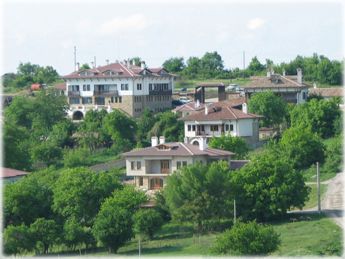
Modern town of
Sozopol -
Map
|
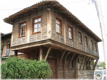
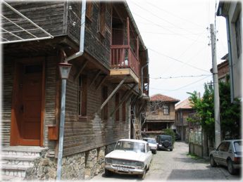
Sozopol - Old Town
Sozopol is one of the earliest towns on the
Bulgarian Black Sea Coast and dates from 2 610 years ago. It is situated
upon a picturesque peninsula. The archaeological findings testify to the
presence of the Thracians as its first inhabitants. In 620 B.C. immigrants
from the rich city of Milet - the largest South Greek centre on the Asia
Minor coast - turned the old Thracian settlement into a rich Hellene
colony - the independent city-state Apollonia-Pontica.Full info here...
See also:
http://en.wikipedia.org/wiki/Sozopol
|
|
|
|
Streets of Sozopol ( The Old
Town )
Just several miles south of Sozopol is located one of the finest
Bulgarian sea resorts - Dyuni : a modern Holiday Village
, comfortable and attractive sea resort situated amidst a fine nature
reserve. It has been awarded the international Blue Flag Award for clean
and safe environment.
More info and Pictures here......(hotels, activities, etc.)
See also:
|
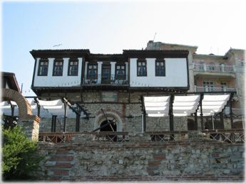
Old Town of Nessebar
Nesebar
is one of
the oldest towns in Europe, well known with its exotic monuments the
Antiquity, its fascinating architecture of the Middle Ages and the
National Revival period. The town is situated on a small rocky peninsula
in the North part of the Bourgas bay.
In 1956 Nesebar was proclaimed an archaeological and
architectural reserve and in 1983 the cultural monuments of the town
were included in the list of UNESCO.
The
area of Nesebar is about 25 ha. It is linked with the new part of the
town by a narrow 300 metres long strip. The beach, based in the new
part, is 4 km long.
More info and Pictures here .. (hotels, activities, etc.)
Info from Wikipedia
|
|
|
|
Tryavna, Gabrovo County -
Map
Tryavna is a city which undergoes its bloom during the Bulgarian
Renaissance when it is an important economic and cultural centre in the
region. In it could be seen many ancient houses, a clock tower, the museum
of the wood cutting and the icon paintings, which is located in the old
school, as well as two magnificent churches with its remarkable
iconostasis and icons.
From the period of the Bulgarian renaissance in
Tryavna is preserved the square.
In front of the church St Archangel
Michael and the square Captain grandfather Nickolai, national Hero. In the
other end is the clock tower.
Full info
and pictures here...
|
Arbanasi, Veliko Tarnovo County -
Map
Arbanassi is a unique settlement, founded in the
end of 15 C. by Christians, who had come from the southwestern parts of
the Balkans. In 1582 it was registered as a vakuf of Rustem pasha. The
Greek language and literature were a uniting factor for the diverse
Christian population. During 17-18 c. the settlement prospered. Its
residents were actively involved with foreign trade and kept close
contacts with Italy, Austro-Hungary, Russia, Vlashko (part of Romania) and
India. They also acted as intermediaries between European cities and
Constantinople. The trade of goldsmiths, coppersmiths, blacksmiths, and
silk-worm breeders developed. The church played a very significant role in
the social life of Arbanassi. There are 5 churches and 2 monasteries from
16 17 c. in the village. Small schools were built later as parts of these
churches. Full
info, map of the location of Monasteries and Churches... here....
|
|
|
|
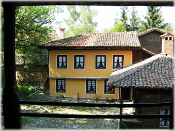
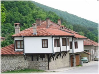
Modern houses in Arbanasi region
Just several miles from Arbanasi is located Veliko
Tarnovo-Veliko Turnovo has been capital of the Bulgarian
Kingdom for more than 200 years from 1185 until 1393. It is picturesquely
situated between the hills of Tsarevets, Trapezitsa, Momina Fortress,
Sveta Gora, and along the banks of Yantra River, the beautiful river
winding around them. This is the reason why the main city of the
Bulgarians used to be described by medieval chroniclers as "the most
inaccessible and marvellous of all towns along Hems". Immersed by the
splendour and glamour of Turnovgrad, European rulers used to call it "the
third Rome and the second Constantinople"...
More info and
Pictures here ...
|
Chiprovtsi, Montana County -
Map
Chiprovtsi is a very old town, settled in the foot of the Stara planina
mountain, 30 km. far from Montana. Through the town flows the Ogosta
river, coming from the high parts of the mountain. The name Chiprovtsi
comes after the Roman name of copper РІР‚ kuprum. It was named
Kiprovets first, then Chiprovtsi (renamed 1956). In Roman times Chiprovtsi
was a major mining center. Excavations have uncovered a catholic monastery
complex dating back to the 15th-17th centuries - bishop's seat of the
Sofia Catholic Eparchy during the time of Petur Solinat, a missionary from
the Order of Franciscans who built and established the Catholic Church in
Bulgaria. In the 16th-17th centuries the monastery is a cultural and
educational centre of the Bulgarian Catholics.
More
interesting info here.. ( about carpet industry)
See also:
http://en.wikipedia.org/wiki/Chiprovtsi
|
|
![]() |